


Marigot vers le Lorrain

GabyG
User GUIDE
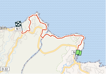

Length
4.8 km

Max alt
65 m

Uphill gradient
136 m
Km-Effort
6.5 km

Min alt
5 m

Downhill gradient
93 m
Boucle
No
Creation date :
2022-06-12 11:35:30.836
Updated on :
2022-06-12 20:16:29.658
2h01
Difficulty : Medium

FREE GPS app for hiking
 SityTrail
IGN / Geographical institutes
SityTrail Plus
The world is yours!
About
Trail Walking of 4.8 km to be discovered at Martinique, Unknown, Le Marigot. This trail is proposed by GabyG.
Description
tronçon du GR, pour rando du dimanche
Photos


Positioning
Country:
France
Region :
Martinique
Department/Province :
Unknown
Municipality :
Le Marigot
Location:
Unknown
Start:(Dec)
Start:(UTM)
711784 ; 1639765 (20P) N.
Comments